The Old Port Trail
The Old Port trail commences at ‘Seabank’,’ on the inlet at the end of the Old Port Road, Langsborough. It passes through heathland and banksia glades to the Old Port Foreshore road, through melaleuca thickets, mangrove swamps and swash ways to Port Albert. It can be travelled in both directions, Parks Victoria estimates the full return walk to take four hours. ‘Seabank’ is located near the present caravan park, at the western end of the trail, where Angus McMillan reached the inlet on 14th February 1841. A cairn marks the spot, a short distance down the trail.
‘Seabank’ is also close to where the original settlement of Port Albert was established by the Gippsland Company in May of 1841.
On the beach you may see remains of crockery and old bottles dating back to the early settlement. The settlement struggled due to the diffident terrain and the shallow channels, moving to the current site, Stockyard Point approximately two years later a much more convenient site for loading cattle.
Why walk the trail?
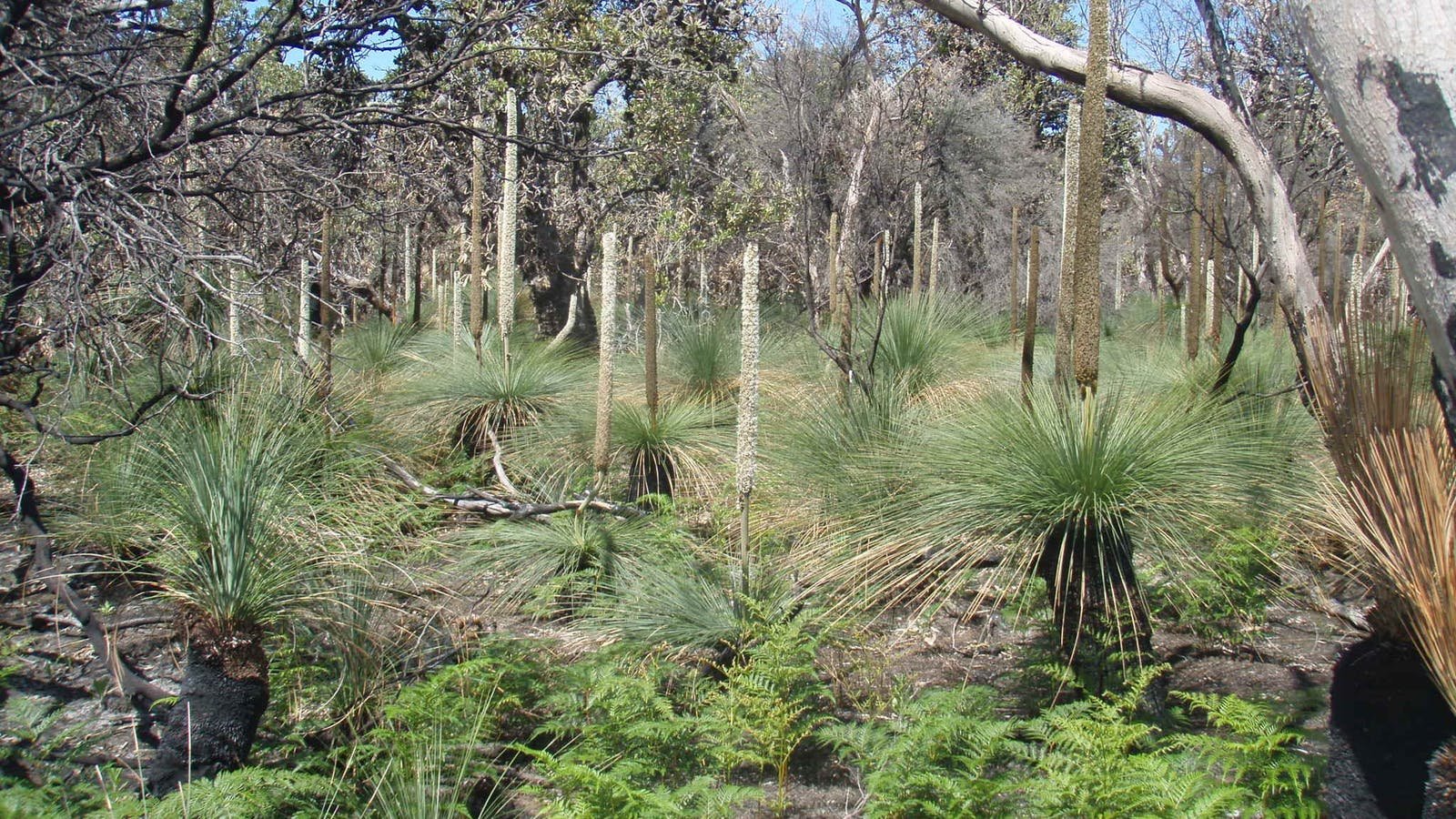
As well as the historic aspect there are fine views across the mud flats and from the lookout, above a crumbling cliff, you have wonderful views across the inlet to Gellion’s Run and Wilson’s Promontory. The vegetation is much as it was in Aboriginal times – small gums, old banksia trees and an amazing range of shrubs and bushes to delight those interested in our native plants. One is sure to glimpse evidence of the abundant wildlife.
If you are lucky you may see a kangaroo or wallaby and if you look carefully, in the sandy patches, you are almost certain to see their tracks. Don’t be alarmed if you come across a snake of lizard sunning itself beside the track. If you leave it alone it will not worry you.
The bush is alive with birds, wrens, robins, thornbills, chats, honeyeaters, ravens, cockatoos and more. The inlet supports a large population of wader birds, which can be viewed from the mud flats. The mud flats also support many shellfish and a variety of crabs and marine life.
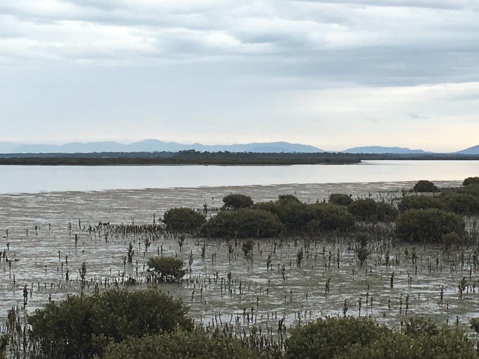
Mangrove and Mud flats
The mangroves of the Nooramunga Marine & Coastal Park are the southern most location of mangroves in Australia.
The mangrove plant is specially adapted to grow in the salty conditions. Its extensive root system with roots coming out above the water, allows the plant to take in the nutrition, water and gasses necessary for survival.
The leaves have special salt secreting glands, which enable the plant to tolerate its salty environment. The mangrove mud flats are an ideal environment for fish nurseries and support an amazing range of marine life.
A few sweeps of a dip net, will reward with shrimps, small fish and crabs. Yabbies’ and worms abound. The mud flats also support the growth of seaweeds and sea grass on whose roots the black swans feed.
A ramble along the 5.7km Old Port Trail from ‘Seabank’ to Port Albert is to take a walk into the past. With very little evidence of European interference, this coastal woodland and heathland is much as it was when the first white settlers saw it in 1841. Until then, it was the domain of the Brataolung clan who fished the inlet in bark canoes, hunted game on the grassy flats and foraged for plant and insect fare.
The Nooramunga Marine and Coastal Park is a wetland of international importance and is listed under the Ramsar Convention. This provides for protected wetlands across the world to support bird migration. Our wetlands are the fourth most important in Australia, providing shelter and food for a wide range of migratory birds, many coming from the Northern Hemisphere. These include a variety of terns, black tailed and bar tailed godwits, dotterels and sandpipers. Birds also migrate across Bass Strait and the Tasman.
The Port Albert Maritime Museum Committee of Management Inc. acknowledges the assistance of Terri G Allen and her publication, ‘Old Port Trail, Individual Learning Pathways,’ from which much of this text has been taken.


 Today it remains a private residence, carefully restored and adapted for modern use. More recent owners have retained its defining features – high ceilings, arched windows, Baltic pine floors, and solid brickwork – while adding an accommodation wing at the rear. The building sits within a 1,597 square-metre block overlooking the historic Government Wharf, its courtyard shaded by mature trees.
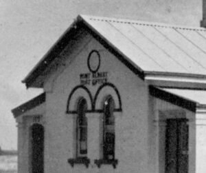 The Port Albert post office was built in a conservative Italianate style, a restrained interpretation of the architecture popular in Melbourne during the 1860s. Its symmetrical façade, bracketed eaves, and tall arched windows gave the small coastal town a touch of metropolitan civility.
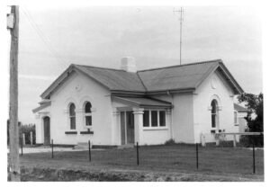 Port Albert’s prosperity peaked in the 1860s. As railways reached inland towns, trade routes shifted, and larger ships bypassed the shallow inlet. The port declined, but the post office endured.
 An Enduring Connection